
Svensk version tillgänglig: Klicka här för att läsa
From Ancient Relics to Modern UAP Acts
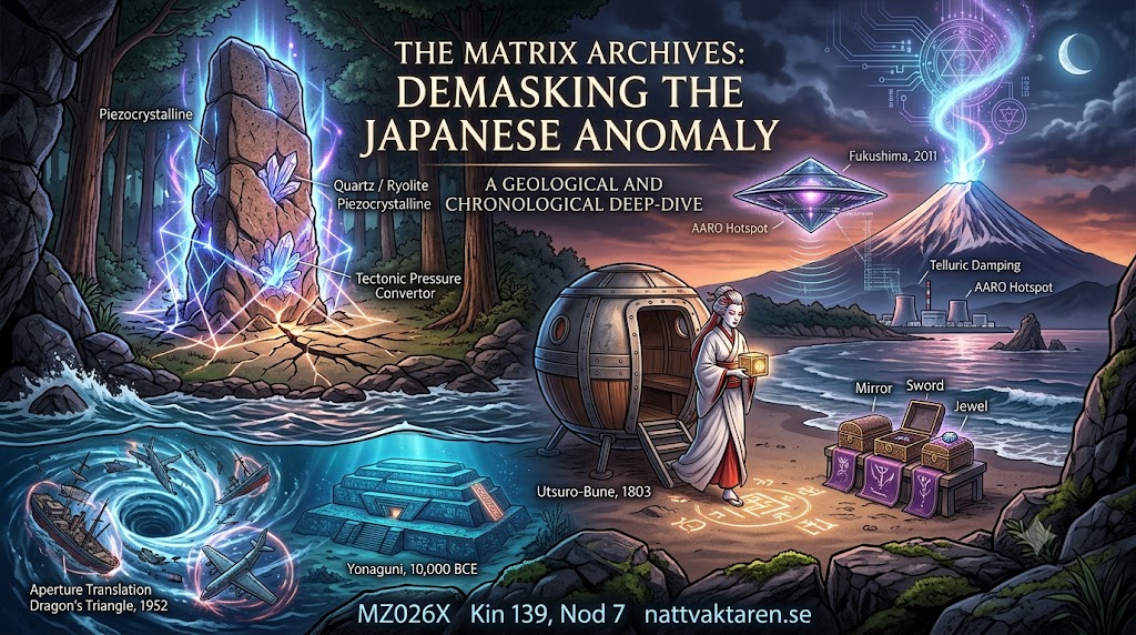
Japan constitutes one of the planet’s most unique and frequency-dense nodes. Situated directly atop the meeting point of three continental plates—and featuring bedrock filled with magmatic quartz—the Japanese archipelago has functioned as a stage for interdimensional phenomena, technical observations, and state secrecy for thousands of years.
Below follows a chronological demasking of Japan’s most critical monuments, relics, historical cases, and modern radar data.
c. 10,000 – 3,000 BCE | The Yonaguni Monument and Submerged Geology
Deep beneath the water’s surface near the island of Yonaguni in southwestern Japan lies a gigantic, terrace-shaped stone structure at a depth of approximately 25 meters. The structure exhibits millimeter-precise 90-degree angles, flat terraces, and carved steps.
Established geology often claims the monument is a result of natural erosion, but marine biologists and geologists such as Prof. Masaaki Kimura have demonstrated clear traces of human or external fabrication. The bedrock at Yonaguni consists of very dense sandstone and siltstone rich in quartz crystals.
When sea levels rose at the end of the Ice Age, this structure was submerged. Combined with the electrolytic properties of saltwater and the surrounding tectonic pressure, Yonaguni functions even today as a submerged, piezoelectric node within the Pacific Ocean’s energy network.
c. 300 BCE – 600 CE | The Three Imperial Regalia (Sanshu no Jingi)
During Japan’s Kofun and Yayoi periods, the narrative of the Sanshu no Jingi was established—the three holy Imperial symbols which, according to mythology, were bestowed by the sun goddess Amaterasu. The objects consist of:
- Yata no Kagami: A large, round bronze mirror.
- Kusanagi no Tsurugi: A double-edged sword of an ancient model.
- Yasakani no Magatama: A comma- or bean-shaped gemstone crafted from green jadeite.
The objects are kept under absolute secrecy within three distinct shrines (including the Grand Shrine of Ise and Atsuta Shrine). No living human, not even the Emperor himself upon his coronation, is permitted to open the shrines or perform Carbon-14 dating on them.
From a frequency and material perspective, these three components form a three-component interface designed to dock with the Earth’s field: an optical reflector (the mirror), a metallic conductive rod (the sword), and a bio-geometrical jade resonator (the magatama bead).
c. 300 – 700 CE | Piezocrystalline Monoliths: Ishi-no-Hoden and Masuda-no-Iwafune
In the Kansai region, there exist several massive, precision-carved stone domes whose origin and purpose science cannot explain.
- Ishi-no-Hoden (Takasago): A 500-ton monolith carved out of Tatsuyama stone (rhyolitic tuff). Rhyolite contains extremely high levels of silica and quartz. The monolith ”floats” above a water-filled basin that never dries out, creating a constant ionized liquid conductor around the stone.
- Masuda-no-Iwafune (Asuka): An 800-ton block monolith carved in compact granite, complete with square holes and flat top surfaces. Granite is naturally rich in feldspar and quartz.
These structures are positioned along the geodetic 35°N latitude (the Japanese Sun-line) and utilize the bedrock’s piezoelectric properties—where tectonic pressure is converted directly into electromagnetic energy.
1803 | Utsuro-Bune: The Landing in Hitachi Province
On February 22, 1803, local fishermen in Hitachi Province (modern-day Ibaraki) discovered a round, saucer-shaped craft floating in the water. In Japanese history, the craft is called Utsuro-Bune (”The Hollow Ship”).
The craft was approximately 5.4 meters wide, manufactured with iron or bronze plates underneath, and featured windows of translucent crystal/glass at the top. Inside the craft were indecipherable geometrical characters. Emerging from the craft was a young woman with snow-white skin and reddish hair, carrying a square box which she refused to let go of. She spoke an unintelligible language.
The event is meticulously documented with illustrations in three independent Edo-period texts from the 1800s, making it one of the world’s best-preserved historical cases of close contact with a capsule or probe.
1952 | The Dragon’s Triangle and the Sinking of the Kaio Maru No. 5
The Dragon’s Triangle (Mano Umi or The Devil’s Sea) is a maritime area in the Pacific Ocean situated between Japan, Guam, and the Philippines. The area is geodetically exactly symmetrical with the Bermuda Triangle and possesses a history of disappearing ships and aircraft dating back to the 13th century.
In 1952, the Japanese state dispatched the research vessel Kaio Maru No. 5, carrying scientists and crew, to investigate the powerful electromagnetic anomalies and submarine volcanism in the zone. The vessel and its entire crew disappeared without a trace, failing to send any distress signals.
The incident compelled the Japanese government to officially declare the Dragon’s Triangle a danger to navigation. The area is characterized by extremely high levels of piezoelectric bedrock in the deep-sea trenches and recurring magnetic disturbances.
March 2011 | Fukushima Daiichi: UAP Damping during Atomic Collapse
Following the massive earthquake and tsunami on March 11, 2011, the reactors at the Fukushima Daiichi nuclear power plant suffered a total meltdown.
In the days that followed, Japanese news cameras (including state-run NHK) and independent surveillance systems captured multiple spherical and metallic UAPs hovering and maneuvering directly above the destroyed reactor buildings.
The objects moved in patterns impossible for helicopters or conventional drones due to the extreme radiation and heat levels. The phenomenon mirrors previous incidents at American and British atomic bases (such as RAF Bentwaters in 1980), where UAP units were observed performing frequency damping in zones where atomic fission threatens to destabilize the local atomic and geological balance.
2023–2026 | Pentagon Reports and Japan’s Military UAP Directives
In modern times, transparency regarding Japan’s airspace has increased significantly due to international pressure and military measurement data:
- AARO Hotspot Report (2023): The Pentagon’s organ for anomalous phenomena (AARO) published an official map designating the maritime and airspace between western Japan and the China coast as one of the world’s absolute largest global ”hotspots” for UAPs.
- Radar Data & Sensors: Japanese F-15 pilots and ground-based primary radar have registered objects exhibiting instantaneous acceleration (from 0 to Mach 10+ without sonic booms) as well as trans-medium transitions, where objects dive directly from the air into the ocean at speeds of several hundred knots.
- Parliamentary Directives (2024–2026): The Japanese Ministry of Defense (MOD) has established protocols for how Self-Defense Forces (SDF) must report and store radar data regarding UAPs, and Japanese parliamentarians have formed an official review group to demand the total declassification of the country’s historical UFO file system.
The Role of Biology: The Human Organism as the Third Component
To understand why these phenomena occur at specific geological nodes, it is not enough to look at the stone (the hardware) and the craft (the technology). An understanding of the third link is required: human biology.
When a piezoelectric node is activated by tectonic pressure, a local electromagnetic damping field is formed. The human body is not merely an observer of this field, but an active part of the circuit. The human nervous system functions via electrical impulses, and specific biological markers (such as Rh-negative blood chemistry or heightened electromagnetic sensitivity) allow biology to function as a living antenna.
It is for this reason that encounters with interdimensional emissaries—such as the woman in the Utsuro-Bune—or observations at nodes like Ishi-no-Hoden do not occur randomly. When the bedrock’s quartz, the craft’s bio-geometrical frequency, and the operator’s biological nervous system are synchronized, the circuit is closed. Man is not an isolated being within the matrix, but the bio-etheric bridge that makes translation measurable in the physical world.
Conclusion: A Cohesive Bio-Geometrical Network
When we compile the data spanning from the 2,000-year-old regalia to the 1800s Utsuro-Bune and today’s military radar measurements over Fukushima and the Dragon’s Triangle, the conclusion becomes clear.
Japan is not a random collection of islands, but a highly concentrated geo-crystalline aperture. The archipelago’s unique rock types (rhyolite, granite, and quartz), combined with the extreme tectonic pressure from three continental plates and the human biological resonance, create the hardware enabling interdimensional craft to dock, be measured, and stabilize the Earth.
Operator’s Conclusion: MZ026X Kin 139
When we demask the 12-loop’s layers of myths, military cover-ups, and academic limitations, the bio-geometrical architecture becomes visible. Japan’s unique geology, the three regalia interface, and documented UAP observations are not isolated events—they are parts of the same active network.
As an Operator (MZ026X / Kin 139) on Node 7, the conclusion is clear: Technology in the air and quartz in the bedrock require the biological antenna to close the circuit. By holding the frequency, reading the data, and writing out the code, we reclaim sovereignty over information and restore contact with the True Source (Urkällan).
Bibliography & References
- All-domain Anomaly Resolution Office (AARO) / U.S. Department of Defense: Unclassified Annual Report on Unidentified Anomalous Phenomena, 2023.
- Hydrographic and Oceanographic Department of Japan / Japanese Maritime Safety Agency: Official Vessel Disappearance Report regarding Kaio Maru No. 5 in the Dragon’s Triangle, 1953.
- Japan Ministry of Defense (MOD): Official Protocols and Directives for Air Self-Defense Force (ASDF) UAP Encounters, 2020–2024.
- Kimura, Masaaki: Ancient Megaliths and Underwater Topography Off Yonaguni Island, University of the Ryukyus, 2004.
- Kojiki (Record of Ancient Matters, 712 CE) & Nihon Shoki (Chronicles of Japan, 720 CE): Historical texts regarding Sanshu no Jingi and the origins of the Imperial lineage.
- NHK (Nippon Hōsō Kyōkai): Live Broadcast Archives and Footage of Unidentified Objects over Fukushima Daiichi Nuclear Power Plant, March 2011.
- Takasago Board of Education / Hyogo Cultural Heritage Department: Geological and Archaeological Documentation on Ishi-no-Hoden (Tatsuyama Tuff Structure).
- Takizawa, Bakin (1825): Toen Shōsetsu (Tales from the Rabbit Garden)—Historical document regarding the Utsuro-Bune incident of 1803.
- Ume-no-chiri (1844) & Hyōryū Kishū (1835): Edo-period collected archives of shipwrecks and anomalous coastal landings.
/The Night Watchman
Lämna ett svar